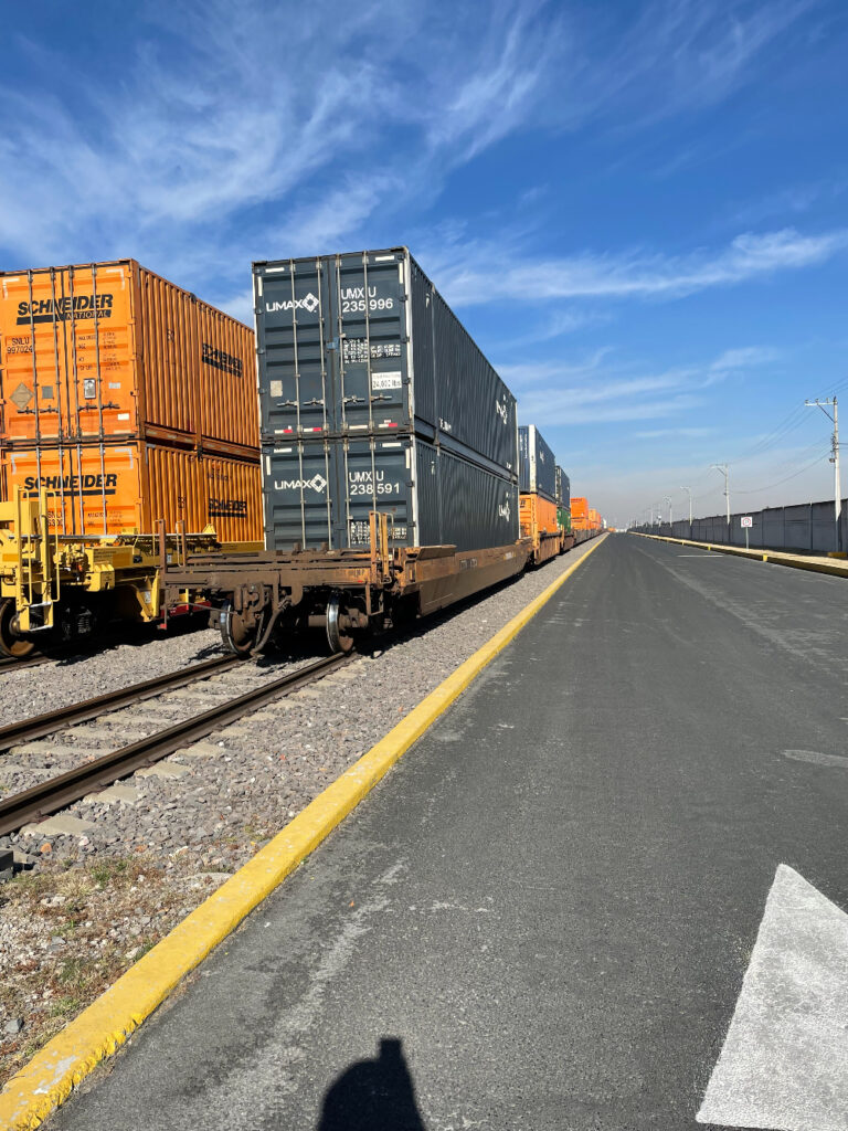
The lack of adequate water runoff over railway embankments in the face of urban changes hampered drainage and led to the closure of all rail freight access to the local port and the rest of Patagonia on March 7, 2025. This is an opportunity to resolve Argentina’s railway logic on a large scale in a region of 9 million inhabitants, 7,000 km of track, four ports, oil, gas, agribusiness, petrochemicals, mining, mass consumption, SMEs, bio-ocean trade with Chile, and 50 million tons of exports.


With the Electronic Signature Platform of our Gold Honorary Partner and strategic ally NOVANDI, we will send you the document so that you can easily sign it.
Opportunity to take a big step forward
The technical writing and this introduction present the integral opportunity for large investments in logistics and railways to decide the reconstruction of 7,000 km (4,450 miles) of tracks in a net with San Juan, Zapala, Bariloche, Pergamino and ports San Antonio Este, Bahía Blanca, Rosales, Quequén. A reconstruction based on a drastic paradigm shift such as those who suffered in the great climate tragedies of the last quarter of a century have achieved. It is the opportunity to reset the railway towards a new paradigm.
Historical consistency
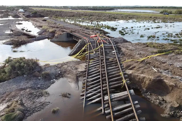
In Bahía Blanca, that 1905 bridge that the image shows, which is crossed in a 1948 canal, is an indicator of the disconnection between the railway and Society, where today not only does it have (or had) embankments, culverts and bridges that were not hydraulically updated to changes in the natural or urban environment, but there was also an abandonment since 1961 of 99% of the production and consumption markets to only limit themselves to squeezing the infrastructure and abandon it when it can no longer support it, and to serve very few clients and the businesses of the concession owners themselves.
Just as hydraulic management did not force the railroad to change that bridge 80 years ago, an entire Society does not force or encourage the railroad to attend to each cargo business in each place, nor to be profitable.
The right question
The challenge is to impose a model that serves the territory’s economy and is productively profitable.
Under these simple premises the question will change from “Where will the money come from?” to “What should the railway business model be like that complies with all of this?”
Based on the US Intermodal Transport Economy model and with the advice of railway professionals from that country and Mexico, the AIMAS team developed the 5F Integrated Railway model and applied it to the case of the North Patagonian, Pampas and partially Cuyo railway network, resulting in an opportunity for a unified investment of between 10 and 13 billion dollars, plus other independent ones in intermodal logistics that will add up to the order of 3 to 5 billion of the same currency.
The application of the model and its execution will lower the operating cost to move 50 million tons annually between the region, the ports, its interior and the border with Chile.
The experience of the North American model and its companies
The US economy has its backbone in the railway and, this, in intermodalism.
In turn, the exchange between the three North American countries has been strengthened since the ’90s due to that same intermodalism and the standardization of the railway game at maximum capacity. They are all very profitable container, truck, port and railway companies.
Urgent commercial, operational and emergency infrastructure advice on and within Argentina’s railway is necessary from proven experts in profitable railways.
Given the total cut between Patagonia and the national and agricultural railway network with its main loading point (Between train, truck and ship hold, 65% of the country’s grain passes through Bahía Blanca), an immediate change of course is needed in which by an agreement based on Law 26,352 Art. 14 Subsection (i), the provinces of Río Negro, Neuquén and Buenos Aires (And San Luis, Mendoza, La Pampa and San Juan should join as interested parties), They will be unified in the same table in agreement with the National Government to introduce provisional commercial, technical and operational advice for six months to redirect management (with or without the current concessionaires), to regain the trust of thousands of customers that the railway does not serve, and then put out to tender a vertically integrated management with the access of hundreds of logistics companies to all the businesses that intermodalism and the 5F model will generate.
“Data is the oil of the 21st century.” The fundamental reset
The phrase in the title corresponds to Adam Basson (tech-logistics businessman from Miami, USA) on his visit to Bahía Blanca and Ingeniero White, almost immediately before the flood. But, if that data is not actually available or is not recorded properly, or is not taken into account, the railway will not be profitable, the logistics will be inaccessible to the economy and the cities will be flooded. The possibility of easily attracting new companies to develop, test and implement solutions for disaster resilience, logistics optimization, transparency, smart infrastructure, collaboration, etc. It can happen immediately now in Bahía Blanca, contributing directly to this reset+reconstruction even better than the previous stage.
The technical summary that makes up this note, exposes the cases of major catastrophes that have occurred in this millennium and which serve as learning to take a new path on the importance of the availability of certain, open and free data for making emergency, prevention, planning and, of course, business and public decisions.
The Bahía Blanca tragedy is already generating many data collaborations through applications carried out by volunteers, organizations and the government, and almost all the municipalities of the railway network in question, as well as the 4 ports, governments, universities, companies and society organizations, have data, frequent registration systems, and many activities that have the data, but it needs to be properly structured.
The AIMAS Association considers that collective action is needed to open, collect and make available and free of charge the greatest possible amount of territorial and georeferenced data, both to resolve emergencies, prevent them and to generate the urgent recovery of the capacity of logistics, mobility, private economy of all sizes and transport in the region of the network of interest..
Conclusion in a single reset
Both the urgent resolution of the accessibility of logistics through Bahía Blanca, as well as that of mitigating the damage of the tragedy, recovering the railway or opening and multiplying the generation and use of data, They are part of the same paradigm shift towards a territorial economy in which the connectivity of the elements will also be that of the organizations and people, with which all will begin to develop more and better businesses in the economic territory of North Patagonia, the South Central Pampas and the South Cuyano of Argentina (And with Chile and the Ocean).

Federico “Fred” Weinhold
Co-founder and member of AIMAS. Intermodal specialist and researcher.
LinkedIn: https://www.linkedin.com/in/federico-fred-weinhold-4667b146/
Mail: [email protected]

Adam Basson
Founder & CEO of FlexChain Holdings. AIMAS Advisor/Liaison to North America
LinkedIn: https://www.linkedin.com/in/adambasson/
Mail: [email protected]

Jorge de Mendonça
Co-founder and member of AIMAS. Pg Transportation Policy and Planning.
LinkedIn: https://www.linkedin.com/in/jdem-intermodal
Mail: [email protected]
Technical Annex I – Bahía Blanca: What happened to the Climate
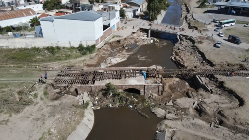
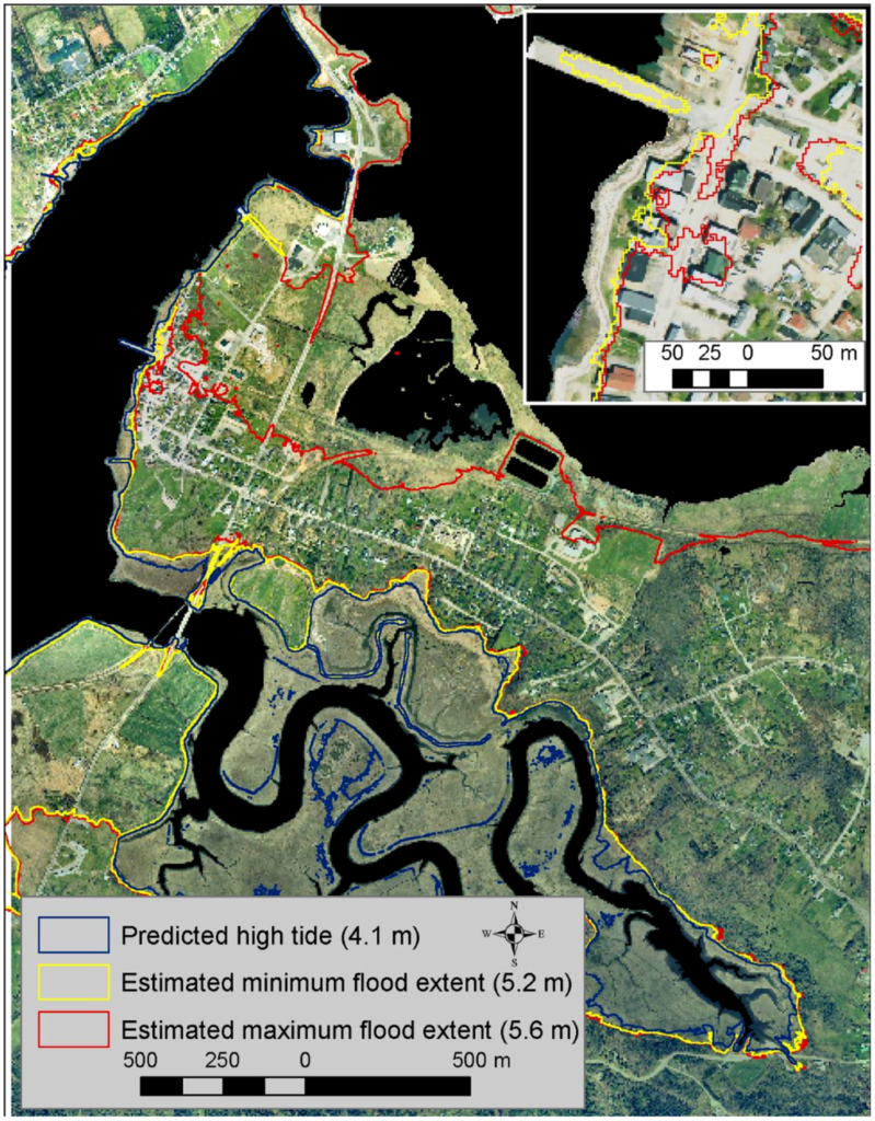
From every point of view, the climatic event that occurred in Bahía Blanca on the morning of March 7, 2025, was catastrophic, but recurring (The events of 1933 and 1944 had a greater amount of precipitation).
The event
On March 7, 2025, the event also affected neighboring municipalities, where a storm system remained practically static, releasing water and regenerating record levels of rain.
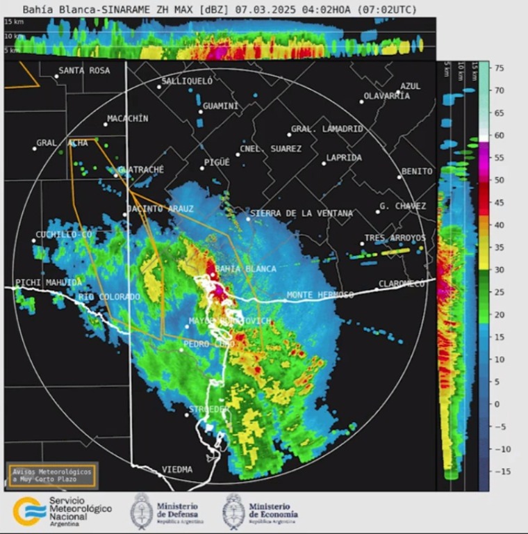
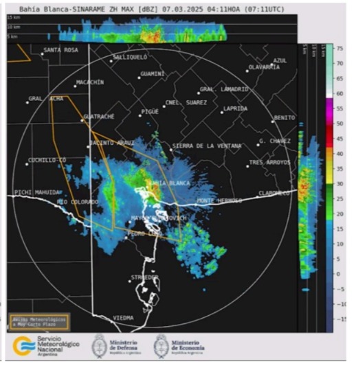
Such was the magnitude that between 04:11 am and 10:29 am the colors of the graphic interface of the National Meteorological Service radar were obscured due to the intensity of the rains (Source: https://www.youtube.com/watch?v=F4ioP_my7ZU ).
In 6 hours the same amount of water fell as in six months.
Radar image at 04:02 am versus 04:11 am
Railway impact
According to the UIC (International Union of Railways) “the activation of rain-related risks depends on the intensity of precipitation and local geography. Although the resilience levels of railway tracks vary depending on the case, studies show that the most serious consequences occurred after rainfall of 150 mm or more in 24 hours” (source: https://uic.org/events/IMG/pdf/future_proof_railways.pdf ). In the case of Bahía Blanca it was 400 millimeters in a period of less than 8 hours.
Within the damages we will focus on the logistics infrastructure that supports and allows the movement of people, cargo, businesses, aid, etc.: The event generated a total cut of roads between Patagonia, the Port and the rest of the Country’s network, therefore generating an opportunity for review far beyond repair.
Research for the article by Federico “Fred” Weinhold – Intermodal Association of South America – AIMAS
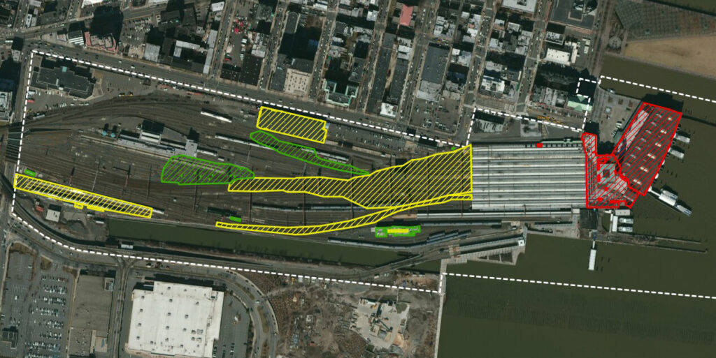
- Source: https://www.diospatial.com/rail-corridor-drainage-mapping/
- Examples of use of LiDAR and other technologies to optimize modeling, decisions, digital twins with detailed environments, etc. in railway, road, port infrastructure, etc.:
- Source of the two previous images: https://www.mdpi.com/2072-4292/16/13/2332 “Automated Flood Prediction along Railway Tracks Using Remotely Sensed Data and Traditional Flood Models”
- https://cordel.ai/lidar-powered-digital-twins-are-ready-to-deliver-on-the-promise-of-intelligent-railways/ “LiDAR-powered Digital Twins are ready to deliver on the promise of ‘Intelligent Railways”
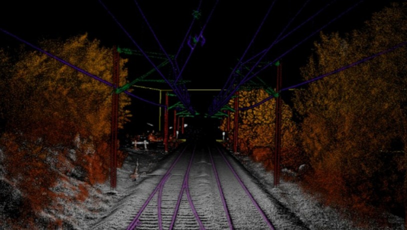
- https://www.thecrossproduct.com/en/blog/lidar-3d-point-clouds-and-more/lidar-le-jumeau-num%C3%A9rique-r%C3%A9plique-virtuelle-gr%C3%A2ce-aux-lasers “LiDAR: The digital twin, virtual replica thanks to lasers!”

- https://www.rtands.com/passenger/lidar-a-tool-for-the-virtual-world/ LiDAR, a tool for the “virtual world”
- Three key words: locate, elevate and mitigate. Source: https://www.tuvsud.com/en-us/resource-centre/blogs/risk-engineering/rebuilding-after-disaster-3-steps-to-strengthen-flood-resilience In order of priority:
- Locate assets outside established flood risk zones.
- Elevate assets above flood risks.
- Mitigate flood risks through passive, active and manual protection strategies.
- In practice, this translates into the following:
- Locate assets outside flood risk areas: Start by identifying all known flood risks that could affect your assets. Use available flood mapping tools, such as those from FEMA in the United States, to understand the proximity of riparian and coastal flood risks to your assets. FEMA maps in the USA, which are part of the Risk MAP (Risk Maps, Assessments and Planning) program, are flood maps that identify risk areas to help reduce them, based on data from the National Flood Insurance Program (NFIP).
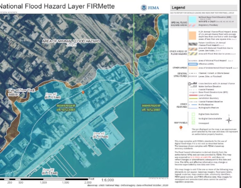
- FEMA map display screenshot example: https://cdn.sanity.io/images/sqn0ww9a/production/520fd7a4121fc8e66ca4f2cbaa9e99f58fce4987-1056×816.png?w=1056&h=816&auto=format
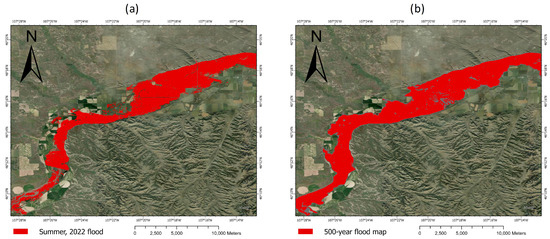
- Raise assets above flood risk levels: If assets such as buildings, equipment, stock and storage, utilities or yard warehouses are in established flood risk zones, elevate them above the flood risk level. For added protection, elevate assets above the 0.2% annual chance of flooding (500-year flood). It is advisable to include additional freeboard, so that assets are at least 0.6 meters (2 feet) above the risk level. In coastal areas, use the latest storm surge maps to assess your exposure.
- Clarification: A «500-year flood» refers to a flood with a 0.2% (1 in 500) chance of occurring in a given year, not one occurring exactly once every 500 years. It is a statistical term that represents the probability that a flood will exceed a certain magnitude.
- The occurrence of a 500-year flood in one year does not decrease the probability of another occurring the following year.
- The 500-year flood designation refers to the probability or possibility of a flood of that magnitude occurring in a given year, not the frequency of occurrence.
- Understanding flood levels, such as the 500-year flood, makes it easier to assess risk and plan for potential flood impacts.
- It is a common misconception that a 500-year flood only occurs every 500 years. This is incorrect; The risk exists every year.
- It is a regulatory standard used by federal agencies to administer floodplain management programs and serves as the basis for insurance programs throughout the United States.
- Mitigate flood risks with passive, active and manual strategies: Most flood protection measures combine elevation and mitigation.
- Flood mitigation strategies can be grouped into three categories: passive, active and manual.
- Passive protection, such as engineered flood barrier walls or earthen embankments, does not require manual intervention. These defenses are always installed, although they require regular inspections and maintenance.
- Active protection, such as bilge pumps or water-activated flood barriers, relies on mechanical and electrical systems, which require regular inspection, testing and maintenance. Backup power systems will help ensure reliability.
- Manual guarding involves gates and barriers that must be installed or closed manually. While effective when implemented correctly, manual systems require trained personnel to act quickly before flooding occurs. Regardless of the combination of strategies you choose, it is essential to have an up-to-date Flood Emergency Response Plan in place. From homes to industrial facilities, a well-implemented plan significantly reduces the risk of catastrophic flood damage.
- Freight rail and climate resilience according to the AAR (Association of American Railroads). Source: https://www.aar.org/issue/extreme-water/#
- Railroads are taking all necessary precautions to protect their employees, infrastructure and customer shipments in the face of an approaching storm and potential flooding.
- Working closely with various partners, such as the Federal Emergency Management Agency (FEMA), the Department of Transportation (DOT), and the Federal Railroad Administration (FBA), railroads are monitoring potential impacts and initiating preparations. Shared information, such as emergency declarations, regulatory waivers, and response plans, is compiled into digital, real-time “Storm Information Dashboards.”
- Examples of Dashboards that combine climate information with transportation assets and infrastructure:
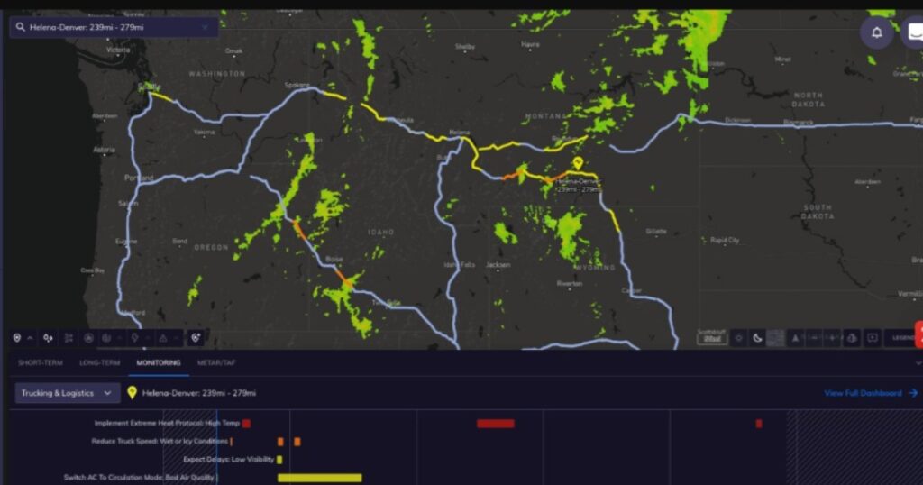
- Asset response system for flood forecasting. Source: https://bemsys.com/ffars/
- The system pictured is called FfARS™ (Flood Forecasting Asset Response System). Using real-time meteorological and hydrological storm forecasts from multiple sources, FfARS™ can project flood levels and timing up to 96 hours before landfall, based on the location and elevation of specific assets. These critical hours before a storm provide the opportunity to implement early flood mitigation and asset conservation measures.
- Taking the paper “Real-time flood inundation forecasting and mapping for key railway infrastructure: a UK case study” by Alexandra T. Murphy presented at the European Conference on “Flood Risk Management” we find:
- “Two-dimensional hydraulic flood models have been widely used for flood mapping for more than a decade. With adequate data, they have proven to be able to reproduce the dominant characteristics of flooding in terms of depth and velocity of water in the flooded area.. Therefore, they have been used to simulate historical floods, analyze flood risk, and map floods. However, in principle,o there is no reason why these models cannot be used in real time for flood mapping. Previously, one of the reasons that limited the adoption of these real-time models was the excessive calculation time. With the significant increase in computational resources and new coding techniques now easily accessible, this challenge has diminished to some extent. Using these real-time models can help decision makers by providing forecasts of flood extent and depth. “These forecasts provide a stronger evidence base to guide mitigation measures, including road closure decisions.”
- Intelligent automation based on a machine learning pattern recognition model to detect and predict the deterioration of railway switch supports. Which can be used in various situations, especially floods. Non-linear finite element models, validated by real field measurements, are implemented to simulate the floods and train the machine learning models.
- Those responsible for railway maintenance will be able to optimize the plan for better management in terms of time, cost and quality. Railway operations will improve in terms of availability thanks to the lower incidence of serious damage.
- In the end, maintenance is performed correctly and operation is not affected by serious damage or prolonged maintenance, as inspection and measurement can be performed at the same speed and on the same schedule as regular operations. Furthermore, installing sensors is relatively inexpensive compared to other approaches, such as the use of road-specific measurement vehicles.
- In practice, rail operators can install accelerometers or cameras to measure crossing nose displacement, or both. They can then use the raw data collected by the sensors and feed it into the machine learning model. This model will detect and predict deterioration of turnout support. They can then apply the machine learning model’s prediction to the maintenance standard to determine its priority.
- For example, if deterioration is normal, maintenance can be performed according to the scheduled maintenance plan. If the deterioration is a priority, maintenance must be carried out within the established period according to the level of urgency. example taken from the paper “Automated machine learning recognition to diagnose flood resilience of railway switches and crossings” from 2023 authored by Jessada Sresakoolchai, Mehmet Hamarat and Sakdirat Kaewunruen.
- Taking the Resilience Plan of the United States Department of Transportation in its July 2024 edition, we find some concepts to take into account:
- What aspects of railway infrastructure are affected by water?
- Tracks and ballast: Heavy rain and flooding can wash away ballast, causing tracks to sink, shift or become uneven, which can derail trains. Debris blown by strong winds can clog roads and damage infrastructure.
- Bridges and culverts: Floods can undermine bridge foundations through erosion (removal of sediment around the foundation) or the accumulation of debris that blocks water flow, which can lead to structural failure.
- Bridges and tunnels: Increased flooding can weaken bridge supports due to erosion, where water erodes the sediment around them. Increased hydrostatic pressure caused by rising sea levels can increase the risk of flooding. Consequently, tunnels located near or below sea level have a higher risk of flooding.
- Signaling Systems: High winds can damage overhead lines and other critical components. Flooding can damage the electronics of these systems, causing signal failures and disrupting the ability to safely manage train movement. Snow and ice can obstruct track switches and signals, disrupt electrical systems on rail circuits, and increase the risk of derailments by obscuring tracks or causing ice buildup.
- Railway Embankments: Many railways are built on raised embankments to keep the tracks dry. However, these structures can erode or be damaged by flooding, undermining the roads above.
- The importance of integrating scientific expertise, regulatory oversight and collaboration of all industry actors (including suppliers, clients, chambers, federations, consumers, citizens, etc.) to build a resilient infrastructure capable of resisting, foreseeing and better facing each possible challenge is highlighted.
Conclusion
Bahía Blanca and the region covered by these 7,000 km of roads must take advantage of this situation as an opportunity to rebuild better and beyond its previous state or situation, being more resilient and generating supply for current and future demand, in particular by going to quality standards, load-bearing capacity, asset rotation, combination of modes, height of bridges in working in community with other ports, transportation interests (Mining, mass consumption, bioceanity, etc.) everything we propose taking as an example professionals, companies, theoretical and applied knowledge of an ecosystem like that of North America which each year rebuilds twice the magnitude of all current roads in Argentina and faces a number of disruptive weather events from which it must recover every year.
We can take and ally ourselves with that knowledge with the “Monday newspaper” at our disposal: The bad experience of everything applied to date in Argentina and the experience of those who have a profitable railway, allied to other transport and which, with intermodalism, is the backbone of the economy of their territory.
Research by Adam Basson and Federico “Fred” Weinhold for
Intermodal Association of South America – AIMAS – March 2025
With the Electronic Signature Platform of our Gold Honorary Partner and strategic ally NOVANDI, we will send you the document so that you can easily sign it.
AIMAS – Asociación Intermodal de América del Sur CUIT 33-71609939-9 – Matrícula 44.916 – Organizada: 27/5/2017 – Fundación: 4/12/2017 Alsina 19 6to piso Of. 9/10 – (B8000IHA) – Bahía Blanca – Buenos Aires – Argentina Cel. solo mensajes: +54 9 11 2191 1985 –www.aimas.org.ar |